Today I dusted off my bike, inflated the tires and hit the road for the first time this year. Though I've been off the saddle for a few months, I've been hiking regularly, so I was curious how I would hold up. Different muscles need to get in shape, and my heart didn't seem quite ready for the one steep hill I hit on the connection between Quarry road and Mt Eden, but overall I felt pretty good.
A new addition since the last time I bothered posting is having a G1 and the My Tracks application, it is so much easier now to document my route. Here's the route I uploaded to google maps at the end of the ride:
View Larger Map
Here are the stats it recorded:
Total Distance: 23.70 km (14.7 mi)
Total Time: 1:09:16
Moving Time: 1:04:26
Average Speed: 20.61 km/h (12.8 mi/h)
Average Moving Speed: 22.07 km/h (13.7 mi/h)
Max Speed: 46.83 km/h (29.1 mi/h)
Min Elevation: 58 m (191 ft)
Max Elevation: 228 m (748 ft)
Elevation Gain: 320 m (1051 ft)
Max Grade: 13 %
Min Grade: -15 %
Recorded: Sat Apr 04 14:46:13 PDT 2009
Activity type: cycling
Pierce Road, Mt Eden, and Stevens Creek lead through a really beautiful area, I passed horses, a winery, and a bunch of ridiculous houses with private vinyards. I also passed Montebello which in my opinion is the hardest climb in the peninsula, something to look forward to when I'm in better shape later this year.
Saturday, April 4, 2009
Saturday, October 27, 2007
Catching up
I've been lazy about posting my rides over the past couple weeks. But I think I'll appreciate this log later in life when I move away from this beautiful area back to flat-as-a-pancake Michigan. Here's the info on the last three rides.
1) A while ago, I climbed Page Mill road and headed up Skyline, similar to the route I took the first time I climbed Page Mill, except I approached from the bottom of Page Mill rather than Moody. It inspired my post about climbs. The climb took me 50:50, with the stretch from the bottom up to where Moody meets taking 15:42.
2) A couple of weeks ago, I took a ride up Old La Honda (25 minutes for the climb), and then down the West side of Old La Honda back.
View Larger Map
It's a great core loop to any ride. OLH is not too much of a ball breaker, but long enough that you feel like you've gotten in a good climb. Descending the west side is one of my favorite stretches in the area. You start by winding your way though a shaded redwood grove before opening up to a sunny valley. On a clear day, you can see the Ocean.
Some stats from that ride:
Distance: 40 miles
Ride time: 2:38
Speed: 15 mph avg, 33.9 mph max
3) Last weekend, I started off towards Arastradero unsure where I'd go. On that route, you get to a fork where you can either head through Arastradero preserve, or climb up Page Mill.
View Larger Map
I decided to climb Page Mill. However, after the short stretch to where it meets Moody, I changed my mind :) At that point, you are usually starting to get tired, and know you are only about a quarter of the way up. I decended Moody instead. At the bottom of Moody, I cut into the ritzy neighborhoods of Los Altos Hills for a short stretch.
View Larger Map
It took me back up into the hills with some nice views of the valley, some amazing houses, and a Ferrari that drove past. After looking at the map, I realize now I could have head further into the neighborhoods and connected with Magdelena; I'll have to try that sometime.
After getting back to Foothill, I headed down towards Los Altos for a while then turned back and headed home. I was getting bored. It's hard to get much distance if you don't head up to Skyline.
Distance: 30 miles
Ride time: 1:45
Speed: 14.4 mph avg, 29.3 mph max
Heart Rate: 145 bpm avg, 185 max
Calories burned: 1483
Sunday, September 30, 2007
It's all about the climbs
When I reflect on a day of riding, the climb I did that day is what sticks out. If my route included no serious climbs of at least 1000 feet, it almost seems like it doesn't count, kind of like going to a Lynyrd Skynyrd concert and having to leave before they play, "Free Bird". In addition to being the most challenging part of a ride, a climb is what brings you to great views and exhilarating descents.
The South Bay Peninsula area I ride each weekend has several famous climbs going up to Skyline boulevard, either from the bay side or from highway 1 on the ocean. The three I've done so far are Kings Mountain Road, Old La Honda, and Page Mill.
Old La Honda and Kings Mountain are both shaded steady climbs with nearly identical grade ascending from different parts of Woodside. On a steady climbs I can pretty much just keep a target heart rate (between 170 and 180) and see how long it takes me.
Old La Honda:
Kings Mountain:

Note that Kings Mountain is about a mile longer.
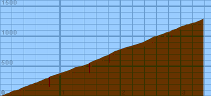
Compared to Kings and Old La Honda, Page Mill is a bit of a ball breaker. In addition to being mostly unshaded, it has much more severe grade in parts, and extends for 8 miles:

In contrast to the almost perfectly steady grade of Kings and OLH, Page Mill alternates between climbs and small flats / down hills. Some of the climbs are very steep, requiring me to dip into the granny gear, something I manage to avoid on Kings and OLH. The variation requires a little bit more concentration. The very steep parts wipe me out, so when I get a break on the flatter parts, I try to recover, but also attack a bit, since it is possible to get up a fair amount of speed and get a bit of a breeze to cool off. Attack to hard, however, and I risk not making it up the next incline.
I look forward to getting up the balls to go down to the ocean and back, which will open up a few more climbs to try out. Tunitas Creek is the most appealing at the moment.
The South Bay Peninsula area I ride each weekend has several famous climbs going up to Skyline boulevard, either from the bay side or from highway 1 on the ocean. The three I've done so far are Kings Mountain Road, Old La Honda, and Page Mill.
Old La Honda and Kings Mountain are both shaded steady climbs with nearly identical grade ascending from different parts of Woodside. On a steady climbs I can pretty much just keep a target heart rate (between 170 and 180) and see how long it takes me.
Old La Honda:
Kings Mountain:
Note that Kings Mountain is about a mile longer.
Compared to Kings and Old La Honda, Page Mill is a bit of a ball breaker. In addition to being mostly unshaded, it has much more severe grade in parts, and extends for 8 miles:

In contrast to the almost perfectly steady grade of Kings and OLH, Page Mill alternates between climbs and small flats / down hills. Some of the climbs are very steep, requiring me to dip into the granny gear, something I manage to avoid on Kings and OLH. The variation requires a little bit more concentration. The very steep parts wipe me out, so when I get a break on the flatter parts, I try to recover, but also attack a bit, since it is possible to get up a fair amount of speed and get a bit of a breeze to cool off. Attack to hard, however, and I risk not making it up the next incline.
I look forward to getting up the balls to go down to the ocean and back, which will open up a few more climbs to try out. Tunitas Creek is the most appealing at the moment.
Sunday, September 23, 2007
Old La Honda and Cañada, Pics from Last Week
Last week I brought my camera with me on a 35 mile ride that included a climb up Old La Honda and a stroll through Arastradero Preserve:
The map view is pretty neat too. These photos might help explain why anyone would want to spend 2-3 hours sitting on a bicycle seat :)
Today I went on pretty much the same route with an extension down to the end of Cañada and back.
The route.
It was between 60 and 70 degrees and overcast with a few sprinkles of rain until the sun burned through while I was on Cañada. I beat my previous best time up Old La Honda by about a minute, making it up in 24:36. As it has gotten cooler, it's been easier. I burn less calories per mile, and drink a lot less water. When I get home, I'm tired, but not completely wiped.
Distance: 49.3 miles
Ride time: 3:15
Speed: 15 mph avg, 31.5 mph max
Heart Rate: 142 bpm avg, 182 max
Calories burned: 2423
Sunday, September 9, 2007
Old La Honda
On Sunday I took a ride through the usual Woodside / Portala Valley area. There were two novel things about the ride though. The first is that I climbed Old La Honda Rd for the first time, and the other was that I rode pretty early in the morning, leaving around 7:45 AM, instead of the usual 11 AM. Old La Honda is a beautiful shaded climb. It has a similar grade to Kings Mountain Road, though about three quarters of a mile shorter. It's a perfect climb for a shorter ride, as it spits you out on Skyline pretty near La Honda, the best way to descend back down. Overall, a nice way to get a solid climb in without being gone for 3+ hours.
The route.
Going early was kind of nice. It was between 55 and 60 most of the ride, which surprisingly didn't feel too cold, and in fact was kind of welcome after last week's insane heat. It was before the sun had burned off the morning fog, making for a beautiful view at the top of the climb where beams of sunlight were starting to peak through. I need to start bringing my camera.
I did the climb in 25:39, which, judging by some times posted by a local cycling organization, isn't particularly impressive given that I would have barely beaten the dude on the unicycle. By the way, I came across that guy last week on Cañada road and forgot to mention it, he was hauling ass! Anyways, I'm glad I found some benchmark times, I'll see how I do in the coming weeks.
Distance: 33.4 miles
Ride time: 2:13
Speed: 15.0 mph avg, 32.5 mph max
Heart Rate: 147 bpm avg, 179 max
Calories burned: 1815
Sunday, September 2, 2007
O Cañada!
Last Sunday Matt and I wanted to go for a long ride, but wanted to avoid going up to Skyline to avoid the crazy holiday weekend traffic. To get the distance, we basically took the route from the week before through Woodside and Portola Valley and extended it by going all the way down Cañada (according to everyone around here, pronounced 'ken-yada') and back, and then up Page Mill and back down Moody.
The route.
I liked going down Cañada well enough, it was nice to go right past the Crystal Springs reservoir I usually go by in my car on the way to Half Moon Bay. Plus, on Sunday's the park service closes down a stretch of it from cars.
Too Hot For Hills
It was a really hot day, in the high 90s and low 100s. For some reason, I was feeling pretty good though about 35 miles, which is why when we reached the Arastradaro and Page Mill intersection, I agreed to go up Page Mill to Moody rather than simply heading home down Arastradaro. Bad idea. Though I think going up Page Mill then down Moody is easier than the other way around since Moody rd is so steep, it was enough to do me in on Sunday. Part of the reason 100 degrees is tolerable when cycling is I'm usually going between 15 and 20 mph, and the breeze keeps me somewhat cool. When climbing a hill at 5-6 mph, not so much. And of course that was the hottest part of the ride, topping out at 108! I didn't realize how pooped I was until I got to the top and got off my bike, at which point I felt kind of dizzy. The piss warm water in my bottles provided little comfort. I asked Matt how much he would have to be paid to try to climb up the rest of Page Mill, and he thought for a moment before uttering, "a million dollars."
Luckily, it was mostly down hill from there to get home, and after 20 minutes with a bag of frozen peas under my neck laying in front of the air conditioner, I was feeling OK. I'll have to remember though not to do any sort of climbing when it's 100 out.
Distance: 51.1 miles
Ride time: 3:20
Wall time: 4:00
Speed: 15.2 mph avg, 35.4 mph max
Heart Rate: 148 bpm avg, 187 max
Calories burned: 2629
Sunday, August 26, 2007
woodside / portola valley / arastradero loop
I'm planning on going for a ride tomorrow and remembered I hadn't even logged the ride from last Sunday.
the route
Though this loop doesn't have any steep climbs, I noticed the stretch up Sand Hill and on Portola road to Alpine were both tough nonetheless.
Distance: 29 miles
Ride time: 1:47
Speed: 16.2 mph avg, 34.7 mph max
Heart Rate: 141 bpm avg, 172 max
Calories burned: 1310
the route
Though this loop doesn't have any steep climbs, I noticed the stretch up Sand Hill and on Portola road to Alpine were both tough nonetheless.
Distance: 29 miles
Ride time: 1:47
Speed: 16.2 mph avg, 34.7 mph max
Heart Rate: 141 bpm avg, 172 max
Calories burned: 1310
Subscribe to:
Posts (Atom)
